
Among the rolling hills of the Eastside Road of Crabtree Neck you will find the old Ball Field, where for decades children spent hours learning to play ball. The first property that CNLT purchased, the Ball Field preserves a total of 83 acres of open space, forest, and wildlife habitat. Enjoy a hike on the Woods Trail through classic Maine fields and woods, or visit the old apple orchard behind the Community Garden which the community gardeners are working to restore. Sightings of wild turkeys, deer, foxes, and a variety of bird species happen here. Most recently, bluebird boxes can be seen dotting the landscape.
The Woods Trail runs from the Community Garden on Eastside Road (which has parking) to Point Road through two CNLT properties: The Ball Field (60 acres) and the Sam Ball Woods (23 acres).
Sam Ball Woods Preserve
The Sam Ball Woods Preserve is named after Samuel Ball who established a farm here in the late 1700s. The 23-acre preserve is now forested, but if you look closely you can see parallel mounds and ditches stretching through the woods. These are the vestiges of the historic Ball strawberry farm. Trails wind through the woods connecting the Point Road to the Community Garden on the East Side Road. The trailhead on the Point Road is located just north of the Hancock Point School and is marked by a large sign visible from the road. No parking is provided at the trailhead.

Ball Field Preserve Management Plan
This management plan addresses three preserves: Ball Field, Hartson Woods and Sam Ball Woods. These preserves are commonly referred to as the Ball Field Preserve.
Location
The Ball Field Preserve, Hartson Woods Preserve and Sam Ball Woods Preserve are located within the interior of Crabtree Neck south of the Cross Road.
Property Description
This management plan addresses three preserves: Ball Field, Hartson Woods and Sam Ball Woods. These preserves are commonly referred to as the Ball Field Preserve. The Preserves consist of approximately 90 acres of mixed woodland with more than 1.6 miles of trail. The topography is gently sloping with elevation ranging from approximately 75 to 115 feet above sea level. The US Fish and Wildlife Service has identified about 13.5 acres of the Preserves as forested wetland and 1.1 acres as scrub wetland. A historic woods road crosses the Ball Field and Sam Ball Woods Preserves from east to west. The Woods Trail on the Ball Field Preserve follows a portion of the road.
Access
Primary access is provided by the parking lot at the Community Garden on the East Side Road. This unimproved lot has more than adequate capacity (over 20 vehicles) to serve the Community Garden and trailhead parking. A signed trailhead is located near this parking lot. A signed trailhead is also located on the Point Road, but no parking is provided. No trailhead exists on the Cross Road. The Preserves have 1.6 miles of trails that are open for walking and biking. Bog bridging provided through wet areas is constructed as double, parallel laid planks.
Natural Resource Summary
Geology
The geology of Crabtree Neck is comprised of the Ellsworth Formation. This formation started around 500 million years ago as sediment and volcanic materials deposited on an ancient ocean bed. Plate tectonics forced the crust of this ocean beneath an adjacent plate. As the sediments were folded and uplifted, this material metamorphosed into schist and gneiss. Ellsworth Schist is dark green or gray, complexly folded and streaked with lighter colored layers of quartz and feldspar. During the most recent ice age, the schist bedrock was scoured by glaciers that were over 3,300 feet thick. The glaciers smoothed the landscape while leaving behind an unsorted mixture of clay, sand, gravel and boulders known as “glacial till.” As the glaciers melted, the weight of the ice was lifted and the earth’s crust, which had sunk under the weight of the thick ice, gradually rebounded. Coastal Maine rose above sea level between 12,000 and 11,000 years ago (Gilman, et al. 1988). As the land rose, the sea retreated to about 180 feet below the current sea level thus exposing lands far beyond the coast we see today. Gradually, as the continental ice sheet continued to melt, the sea level rose. Around 2,000 years ago, the rising ocean reached the present level, and the current coastline of Crabtree Neck was established.
Soils
Soils found on the Preserves are described by the United States Soil Survey as being formed by glacial activity. The parent material (original geologic bedrock or deposit) from which these soils have formed is primarily from the glacial till and sediment deposited by glaciers. In some areas where the glaciers left bare bedrock, soils formed from the bedrock itself. Portions of the Preserves and notably the eastern portion of the Ball Field Preserve are mapped by the Soil Survey as Tunbridge-Lyman complex, which is classified as prime farmland (Map 4). Prime farmland, as defined by the U.S. Department of Agriculture, is land that has the best combination of physical and chemical characteristics for producing food, feed, forage, fiber, and oilseed crops. The Ball Field Preserve also has an area mapped as Colton gravelly sandy loam, which is classified as Farmland of statewide importance. This classification of soils indicates soils that that are nearly prime farmland and that economically produce high yields of crops when treated and managed according to acceptable farming methods. The remaining soils on the Preserves are identified as not prime farmland.

Habitat Types
Lower-elevation Spruce – Fir Forest
This is the most common forest type, dominated by red spruce with some balsam fir and white pine. The understory is sparse with balsam fir and red spruce in more open areas. Ground cover is a mix of bare conifer litter and patchy to full bryophytes (three-lobed bazzania and red-stemmed, plume, and hair cap mosses). The US Fish and Wildlife Service has identified about 13.5 acres of the forest on the Preserves as forested wetland.
Alder Thicket
This shrub dominated wetland is restricted to locations along small streams and wet areas, and is dominated by speckled alder, with an herb layer of cinnamon and sensitive fern, sedges and bluejoint grass. The US Fish and Wildlife Service has identified about 1.1 acres on the Preserves as scrub wetland, which consists primarily of Alder Thicket.
Tall Grass Meadow
Tall Grass Meadow is located in wet areas on the Sam Ball Woods Preserve and mixes with alder thickets. It is comprised primarily of bluejoint, with aster and meadowsweet.
In addition to these habitat types, open meadows with blueberries are maintained on the Preserves. Most of the open meadows are on the east side of the Ball Field Preserve. Because these meadows are maintained, they do not adhere to a natural community and would revert to forest if not maintained. The fields between the forest and the Community Garden have been mowed every few years to foster the growth of blueberries, which grow well in this area and are picked by many visitors.
Wildlife
Wildlife that frequent the Preserves include deer, fox, coyote, bear, porcupine, snowshoe hare, red squirrel, turkey, grouse, and barred owl. Nesting birds include chickadees, warblers and thrushes.
Invasive Species and Control Options
A small clump of Japanese barberry, Berberis thunbergii, is located near the orchard on the Ball Field Preserve . Plants have been pulled out, but additional monitoring and maintenance is needed. There is a rotten log near the clump that should be removed so it does not interfere with the mowing of the field.
No other invasive species have been identified on the Preserves.
Land Use History
The first humans arrived in Maine as the glaciers retreated about 12,000 years ago. These Paleoindians found a landscape of grassy plains and tundra interspersed with willow, alder and spruce populated with wooly mammoths, mastodons, caribou and giant beavers. Over time the habitat of Maine shifted from plains to boreal forest. During this time, around 9,500 years ago, the cultural attributes associated with Paleoindians (such as Clovis spear points) disappear from the archaeological record. The Archaic Period (9,500 to 3,000 years ago) found people adapting to a warming climate that brought a forest of mixed hardwoods and softwoods. As the environment stabilized, small bands settled into a seasonal pattern of regular hunting, fishing and gathering sites. Archaic people relied on an increasingly diverse variety of animals (including smaller mammals, anadromous fish, shellfish, and marine mammals) and plants (roots, seeds and nuts). During the latter part of this period, the Red Paint People appeared on the coast (5,000 to 3,500 years ago). This culture gained its archaeological identity from the iron oxide used to cover grave vaults, which also included ritual slate spear-points, lance tips, charms, amulets and ornaments. The Ceramic Period (3,000-500 years ago) began with the introduction of pottery as well as agriculture and the birch-bark canoe. During this period, people increasingly relied on coastal and marine resources. In the 1500s and 1600s, when Europeans first landed on the coast, Maine was settled by the Wabanaki people. Today, the tribes of Penobscot, Passamaquoddy, Mi’kmaq, Maliseet and Abenaki make up the Wabanaki Confederacy.
Traces of the Wabanaki people and their ancestors have been found on Crabtree Neck. Shell heaps found near the present-day locations of Tidal Falls (aka Sullivan Falls) and Riverside Cemetery and at a point off Jellison Cove Road, mark sites where Indians camped repeatedly for many years and discarded clam shells.
Europeans began arriving on the coast of Maine in 1524, with both the English and French making claims to Wabanaki territory. This led to a long period of conflict between the two nations, their competing colonies, and the Wabanaki. The Wabanaki were greatly reduced by waves of disease spread by the Europeans, their numbers declining from about 20,000 in the early 1600s to around 900 in 1760 (Penobscot Marine Museum, 2012). George Varney, in his Gazetteer of the State of Maine, states that there was evidence of an old French settlement at Waukeag[1], an old place name for the Sullivan area. Varney recorded that “an earthen pot, containing somewhat more than $400 in French coin was dug up. They bore the date of 1725”. Varney also states that indications of French settlements were found at Crabtree’s Neck (Varney, 1886). Between 1675 and 1763, a series of six wars were fought between the British and the French/Native Americans. The final war, the French and Indian War was ended by the Treaty of Paris in 1763. Under the treaty, France abandoned all claims to territory in North America. This cleared the way for Anglo-American settlement of Downeast Maine (Penobscot Marine Museum, 2012; Maine Historical Society, 2010).
The first permanent Anglo-American settlement of Crabtree Neck began in 1764-65. The first settlers consisted of Captain Agreen Crabtree and Philip and Shimuel Hodgkins on the Skillings River, where they built a sawmill and grist mill near Hills Island. A map of the region published in 1776 shows six settlements on Crabtree Neck, four along the Skillings River and two on Taunton Bay (Map 5). Crabtree Neck was initially part of the Town of Sullivan, which was incorporated as a town of the State of Massachusetts in 1789. Maine seceded from Massachusetts in 1820, and the Town of Hancock was subsequently incorporated in 1828.

The Town of Sullivan was surveyed in 1803 under order of the General Court of Massachusetts, with settlers provided properties of 100 acres for a payment $5.00. By superimposing the current boundaries of Preserves on the 1803 plan of settlement, the current preserves contains portions of the lots settled by Samuel Ball, Jacob Rust, Paul Blaisdell, Agreen and George Crabtree, and Morgan Jones (Map 6). In addition, a portion of the Ball Field Preserve extends onto land that identified only as 584 acres and 34 square rods (a rod being 16.5 feet). George Varney reported in his 1886 Gazetteer of the State of Maine that 9,000 acres of land in Sullivan was given to Bowdoin and Williams colleges. Maps of the original allotment of Crabtree Neck identify 584 acres and 34 square rods of “college land.”[2] Foss (1870) also identifies a lot of land in this area “set off to Bowdoin College. It is now occupied by Daniel Grant.”

Samuel Ball was born on May 8, 1752 in Massachusetts and had moved to Hancock (then Sullivan) by 1793. He died on May 7, 1806 when his canoe upset crossing the Skillings River. His grandson, Henry Ball was born on March 22, 1821 in Hancock and died on February 17, 1890. Henry Ball and his wife Harriet Crabtree adopted their nephew Asa Henry Gordon whose mother died when he was two years old, and who thereafter went by the name of Henry Asa Ball[3]. Henry Asa Ball (1849-1920), farmed strawberries on the property that is now the Sam Ball Woods Preserve[4]. The long parallel mounds and ditches where strawberries were grown can still be seen on the Sam Ball Woods Preserve. These mounds and ditches can be seen on the west side of the Point Road (adjacent to the Preserve) as well as extending east far into the woods (over 800 feet) on the Preserve. The 1883 Coastal Survey shows open field extending approximately 1,100 feet from the Point Road (Map 7).

The adjacent Hancock Point School is listed on the National Register of Historic Places. The one-room school was constructed in 1870 and was used until 1940. It appears that a church/schoolhouse was established here as early as 1795, with Samuel Ball and his neighbor Captain Stephen Young each deeding ½ acre, and construction provided by Agreen Crabtree (Johnson, 1953). A road extended to the school from the East Side Road as shown on a map prepared by Sumner Hazlewood from other older maps[5] (Map 8). This road is still present along portions of the southern border of the Preserves, and forms part of the Woods Trail on the Ball Field Preserve.
North of the Hancock Point School on the Sam Ball Woods Preserve is a building foundation. Near the foundation, the former landowner placed a small sign reading “Well for 1878 to 1890 12 ft. x 24 ft. Home + Store in Front.” The 1883 Coastal Survey shows a building near this location (Map 6). No other records of this home or store have been found.
In addition to farming, other historic land uses of the Preserves would include timber harvesting and grazing. The 1878 Maine Board of Agriculture Survey describes the state of forests in Hancock County:
Originally, pine, spruce, hemlock, birch, beech, maple, ash, cedar, red oak, and hackmatack, were abundant. But the waster of “God’s first temples” came, and before the insatiable chopper’s axe the primeval forests have disappeared, until, excepting the upper branches of Union river, scarcely a representative tree is left, and our once well timbered county, in its old growth is almost treeless; while the demands for stave timber, box stuff, vessel wedges, and fuel for lime kilns, are rapidly divesting it of its second growth (Wasson, 1878).

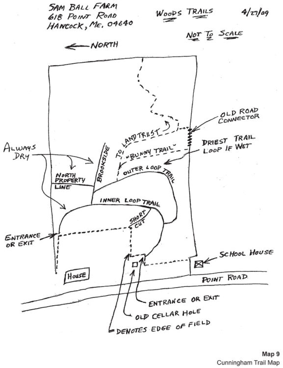
The Ball Field Preserve includes the historic town ball field which is located about 500 feet southwest of the community garden. It is not clear when the ball field was established. The previous owners of the Sam Ball Woods Preserve, Richard and Roberta Cunningham, established trails on the property and created a map of these trails (Map 9). Some of these trails are currently maintained by CNLT. The remaining trails are not maintained or marked, but can still be found along with signs that the Cunninghams made. These signs were made of aluminum flashing with black marker lettering. The lettering is now faded, and the flashing is growing into the trees.
The Community Garden was established by CNLT in 2009 and opened in 2010. There are 41 (12 x 12 foot) plots. Gardeners from the community (mainly Hancock) are provided 1-2 plots on an annual basis. In addition, there are two rows of plots (approximately 14 plots) that are used by Master Gardeners to grow food for the Maine Harvest for Hunger program. Each year the Master Gardeners produce 1,000 to 2,000 pounds of food for donation. Volunteers from the garden deliver the produce to food pantries and community meal programs in Ellsworth.
The garden has a drilled well with a solar powered pump and elevated water tower that feeds a system of hoses and tanks. In addition to the garden, an old apple orchard has been maintained with new trees established in recent years.
[1] Varney (1886) identifies Waukeag as an Indian name for seal. A key source for Varney seems to be A Survey of Hancock County by Samuel Wasson published by the Maine Board of Agriculture in 1878.
[2] The original James Peter’s survey only identifies the remainder as 584 acres and 34 rods; however, at least one subsequent copy identifies the area as “college land.”
[3] Genealogical details from ancestory.com with various sources cited.
[4] Property deed references property as premises of Henry A. Ball.
[5] The map is in the collection of the Hancock Historical Society. A similar map prepared by Sumner Hazlewood is dated 1949
Conservation Values
The Preserves provide an uninterrupted expanse of high-quality wildlife habitat. In addition, the Ball Field Preserve also conserves some of the best agricultural soils on Crabtree Neck. Key Attributes:
- 90 acres of mixed forest and field is the second largest preserve on Crabtree Neck and the third largest preserve in the Town of Hancock.
- The eastern portion of the Ball Field Preserve contains prime farmland and the Community Garden.
- Forested wetlands provide watershed protection.
- Frontage on three roads provides multiple points of connection for trail (but currently is only provided on two roads).
- Ball field is used for an annual event (Little Fenway Day) by residents.
Threats to Conservation
Spruce Budworm
The eastern spruce budworm (Choristoneura fumiferana) is a native insect that causes major damage to Maine’s spruce-fir forests on a regular cycle. Spruce budworm (SBW) caterpillars feed on the buds and needles of fir and spruces. Under normal (endemic) conditions populations of this insect are so low that SBW is hard to find. Periodically the budworm undergoes a population outbreak (epidemic) and becomes so abundant that serious feeding damage occurs. During epidemics defoliation is heavy enough that affected trees produce very little wood and many trees die. These outbreaks occur every 30 to 60 years. The Maine Forest Service has provided the following assessment based on data collected in 2019:
Historical data tell us that Maine is due for another SBW outbreak and monitoring efforts illustrate that over the last several years, SBW population levels appear to have left the endemic or “stable” phase experienced between outbreak events. For several years now in Maine, both pheromone trap and light trap catches have been above numbers expected during the endemic phase and millions of acres of defoliation in neighboring Canadian provinces continues to encroach on the Maine border. Large in-flights of migrating moths from outbreak areas in Canada into northern Maine were well-documented in 2019. The impacts of these migration events on Maine’s forests remain to be seen. (MFS, 2020).
If an outbreak occurs, because the Preserves are mostly spruce-fir forest, there is a significant risk of defoliation and tree loss.
Red Pine Scale
Within the last two years, many red pines on the Ball Field Preserve have been dying. Red pine scale, an exotic invasive insect has been spreading through the region and killed many red pines on Mount Desert Island in 2014. Fortunately, red pine is not an abundant species in the forests on Crabtree Neck and the red pine scale does not affect white pine or other tree species common to our forests. As a result, the loss of red pine trees in our preserves does not present a significant threat to conservation.
Climate Change
The average annual temperature across Maine warmed by about 3.0 °F (1.7 °C) between 1895 and 2014. Since 1895, total annual precipitation has increased by about six inches (15 cm), or 13%, with most of the additional amount falling in summer and fall (Fernandez et al, 2015). These trends are expected to continue, with the region becoming warmer and wetter. However, some climate models predict drier summers (Janowiak, et al, 2018).
Current modeling studies project that the dominant tree species in the region are likely to undergo dramatic range shifts as forests slowly adapt to changes in habitat conditions over the next 100 years. Projections suggest that suitable habitat for spruce-fir forests may virtually disappear from Maine in the next 100 years (Rustad et al, 2012). Under a low-emission scenario, habitat suitability will favor a transition to maple/beech/birch (northern hardwoods) forest, while oak and hickory trees would be favored under a high-emission scenario (Iverson et al, 2008). How forest composition will be affected by climatic changes will be influenced by many factors. The long life span of trees, the slowness with which they disperse, and the possibility that they may adapt genetically to changed climates all make it unclear how soon, if ever, trees will migrate to the places where the models say they should be (Rustad et al, 2012).
Fire
Periods of hot, dry weather occasionally lead to high forest fire risk in the region. The Preserves’ forest has areas of thick spruce and fir that provide a substantial fuel source. Available fuel may increase if a spruce budworm epidemic defoliates and kills spruce and fir trees.
Permitted Activities
Permitted Activities
Gardening, hiking, snow-shoeing and cross-country skiing are permitted during daylight hours. Dogs are permitted but must be kept under control. Hunting is not expressly prohibited.
Restricted Activities
Motorized vehicles are strictly prohibited. No camping or fires are permitted. All trash, including pet and human base, must be carried out. No off-road bicycling is permitted.
References
Johnson, Lois. 2016. Personal Communication, October, 2016.
Fernandez, I.J., C.V. Schmitt, S.D. Birkel, E. Stancioff, A.J. Pershing, J.T. Kelley, J.A. Runge, G.L. Jacobson, and P.A. Mayewski. 2015. Maine’s Climate Future: 2015 Update. Orono, ME: University of Maine. 24pp.
Foss, Thomas. 1870. A Brief Account of the Early Settlements Along the Shores of Skilling’s River.
Iverson, L.R., A.M. Prasad, S.N. Matthews, M. Peters. 2008. Estimating potential habitat for 134 eastern US tree species under six climate scenarios. Forest and Ecology Management. Volume 254, Issue 3, 10 February 2008, Pages 390–406
Janowiak, M.K., et al. 2018. New England and Northern Hew York Forest Ecosystem Vulnerability Assessment and Synthesis: A Report from the New England Climate Change Response Framework Project. USDA General Technical Report NRS-173.
Johnson, Lelia A. Clark. 1953. Sullivan and Sorrento Since 1760. Hancock County Publishing Company, Ellsworth, Maine.
Maine Forest Services (MFS), 2020. Spruce Budworm in Maine 2019. April 1, 2020.
Maine Historical Society, 2010. Maine History Online. Available at: https://www.mainememory.net/mho/; Accessed November, 2016.
Morehead, Warren, K. 1922. A Report on the Archaeology of Maine. Andover, MA.
Penobscot Marine Museum, 2012. Penobscot Bay History Online. Available at: http://penobscotmarinemuseum.org/pbho-1/; Accessed November, 2016.
Pope, Charles, H. 1906. A Pettingell Geneaology. Boston, MA.
Rustad, L., J. Campbell, J. S. Dukes, T. Huntington, K. F. Lambert, J. Mohan, and N. Rodenhouse. 2012. Changing Climate, Changing Forests: The Impacts of Climate Change on Forests of the Northeastern United States and Eastern Canada. USDA General Technical Report NRS-99.
SBW Task Force, 2016. Spruce Budworm. Available at: http://www.sprucebudwormmaine.org/; Accessed December, 2016.
Varney, Geo. J. 1886. History of Hancock Maine from A Gazetteer of the State of Maine, B.B. Russell, Boston.
Wasson, Samuel. 1878. A Survey of Hancock County, Maine. Maine Board of Agriculture Survey. Augusta.
Click on any photo to enlarge and to see a slideshow