
Conveniently located on the Point Road of Crabtree Neck Peninsula about a mile from Route 1, the Pettengill Trail winds through mossy old-growth trees, bog bridges, and deep forest quietude. The 164-acre Pettengill Preserve includes forested and shrub wetlands and wildlife habitat in an area that the Maine Department of Inland Fisheries and Wildlife and the US Fish and Wildlife Service have described as containing “high value” plant and animal habitat.
Pettengill is part of CNLT’s mission to pursue large-scale conservation in this area, fulfilling an essential part of its vision: to save large, unbroken tracts of land that protect highly valued wildlife habitat and maintain the rural character of Crabtree Neck.
Pettengill Preserve Management Plan
by Josh Ferris, Stewardship Coodinator
Location
The Pettengill Preserve is located on the east side of the Point Road approximately one mile south of Route 1 (Map 1).

Property Description
The preserve consists of approximately 150 acres of mixed woodland. The boundary of the preserve is irregular, with a perimeter of 3.2 miles. The preserve has 145 feet of frontage on Point Road but is otherwise bounded by primarily undeveloped land that has been historically used for logging. The topography is gently sloping with elevation ranging from approximately 45 to 115 feet above sea level. A low ridge separates the western sloping half from the eastern half that is level and poorly drained. The US Fish and Wildlife Service has identified about 64 acres of the preserve as forested wetland and 15 acres as scrub wetland. Erratics found on the site provide evidence of past glaciation. Several woods roads cross the site, sections of which have been improved as trails.
Access
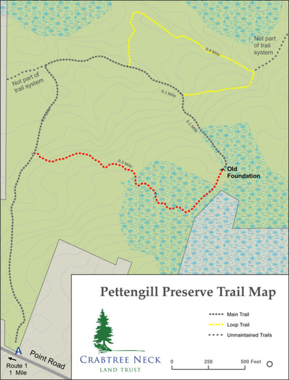
A small trailhead parking lot on the Point Road has space for about three vehicles. A bike rack is located at the parking lot. The preserve has 1.4 miles of trails that are open for walking and biking.
Natural Resource Summary
Geology
The geology of Crabtree Neck is comprised of the Ellsworth Formation. This formation started around 500 million years ago as sediment and volcanic materials deposited on an ancient ocean bed. Plate tectonics forced the crust of this ocean beneath an adjacent plate. As the sediments were folded and uplifted, this material metamorphosed into schist and gneiss. Ellsworth Schist is dark green or gray, complexly folded and streaked with lighter colored layers of quartz and feldspar. During the most recent ice age, the schist bedrock was scoured by glaciers that were over 3,300 feet. The glaciers smoothed the landscape while leaving behind an unsorted mixture of clay, sand, gravel and boulders known as “glacial till.” Larger boulders found on the surface are referred by geologists as “erratics,” as they were deposited by glaciers often at a great distance from their source. Some boulders at the preserve are granite, indicating an origin further inland. As the glaciers melted, the weight of the ice was lifted and the earth’s crust, which had sunk under the weight of the thick ice, gradually rebounded. Coastal Maine rose above sea level between 12,000 and 11,000 years ago (Gilman, et al. 1988). As the land rose, the sea retreated to about 180 feet below the current sea level thus exposing lands far beyond the coast we see today. Gradually, as the continental ice sheet continued to melt, the sea level rose. Around 2,000 years ago, the rising ocean reached the present level, and the current coastline of Crabtree Neck was established.
Soils found on the Preserve are described by the United States Soil Survey as being primarily moderately to poorly drained stony glacial till. In addition, an area of poorly drained silt loam is associated with the wetland on the eastern side of the property. Soil depths are described as up to 65 inches in depth. No prime farmland soils are identified on the property.
Habitat Types
A mixed forest covers the Preserve. Of the natural community types classified by the Maine Natural Areas Program, six are present on the Preserve. Most of the Preserve may be characterized as a transition between Lower-elevation Spruce – Fir Forest and Northern Hardwoods Forest. While there are areas of characteristic spruce – fir forest, the forest does not transition completely to hardwood forest in any area.
Lower-elevation Spruce – Fir Forest
This is the most common forest type, dominated by red spruce with some balsam fir and white pine. The understory is sparse with balsam fir and red spruce in more open areas. Ground cover is a mix of bare conifer litter and patchy to full bryophytes (three-lobed bazzana and red-stemmed, plume, broom, and hair cap mosses).
Northern Hardwoods Forest
In some places, the spruce-fir forest gives way to red maple dominated forest. Red spruce, northern white cedar, yellow and paper birch are also present. The sapling and herb layer is sparse balsam fir and bare leaf litter.
Evergreen Seepage Forest
This is dominated by northern white cedar with some red spruce, balsam fir, and yellow birch. Small areas of this forest type occur in wetter areas. Ground cover is sparse and includes red-stemmed moss and bunchberry.
Alder Thicket
This shrub dominated wetland is restricted to locations along small streams and wet areas, and is dominated by speckled alder, with an herb layer of cinnamon and sensitive fern, sedges and bluejoint grass.
Tall Grass Meadow
Tall Grass Meadow is located near the alder thicket in a seasonally flooded area not far from the parking lot on the Point Road. It is comprised primarily of bluejoint, with aster and meadowsweet.
Spruce-Larch Wooded Bog
Areas of open canopy bog are in the eastern portion of the Preserve. Trees include red spruce, larch, red maple and alder. Shrubs include highbush blueberry, wild raisin and winterberry. Herbs include interrupted fern, sheep laurel, cotton grass, dewberry and sedge. Byroids include sphagnum and club mosses.
Wildlife
Wildlife that frequent the Preserve include deer, fox, coyote, bear, porcupine, snowshoe hare, red squirrel, turkey, grouse, and barred owl. Nesting birds include chickadees, warblers and thrushes.
Invasive Species and Control Options
No invasive species have been identified on the site to date.
Land Use History
The first humans arrived in Maine as the glaciers retreated about 12,000 years ago. These Paleoindians found a landscape of grassy plains and tundra interspersed with willow, alder and spruce populated with wooly mammoths, mastodons, caribou and giant beavers. Over time the habitat of Maine shifted from plains to boreal forest. During this time, around 9,500 years ago, the cultural attributes associated with Paleoindians (such as Clovis spear points) disappear from the archaeological record. The Archaic Period (9,500 to 3,000 years ago) found people adapting to a warming climate that brought a forest of mixed hardwoods and softwoods. As the environment stabilized, small bands settled into a seasonal pattern of regular hunting, fishing and gathering sites. Archaic people relied on an increasingly diverse variety of animals (including smaller mammals, anadromous fish, shellfish, and marine mammals) and plants (roots, seeds and nuts). During the latter part of this period, the Red Paint People appeared on the coast (5,000 to 3,500 years ago). This culture gained its archaeological identity from the iron oxide used to cover grave vaults, which also included ritual slate spear-points, lance tips, charms, amulets and ornaments. The Ceramic Period (3,000-500 years ago) began with the introduction of pottery as well as agriculture and the birch-bark canoe. During this period, people increasingly relied on coastal and marine resources. In the 1500s and 1600s, when Europeans first landed on the coast, Maine was settled by the Wabanaki people. Today, the tribes of Penobscot, Passamaquoddy, Mi’kmaq, Maliseet and Abenaki make up the Wabanaki Confederacy.
Traces of the Wabanaki people and their ancestors have been found on Crabtree Neck. Shell heaps found near the present-day locations of Tidal Falls (aka Sullivan Falls) and Riverside Cemetery and at a point off Jellison Cove Road, mark sites where Indians camped repeatedly for many years and discarded clam shells.
Europeans began arriving on the coast of Maine in 1524, with both the English and French making claims to Wabanaki territory. This led to a long period of conflict between the two nations, their competing colonies, and the Wabanaki. The Wabanaki were greatly reduced by waves of disease spread by the Europeans, their numbers declining from about 20,000 in the early 1600s to around 900 in 1760 (Penobscot Marine Museum, 2012). George Varney, in his Gazetteer of the State of Maine, states that there was evidence of an old French settlement at Waukeag[1], an old place name for the Sullivan area. Varney recorded that “an earthen pot, containing somewhat more than $400 in French coin was dug up. They born the date of 1725”. Varney also states that indications of French settlements were found at Crabtree’s Neck (Varney, 1886). Between 1675 and 1763, a series of six wars were fought between the British and the French/Native Americans. The final war, the French and Indian War was ended by the Treaty of Paris in 1763. Under the treaty, France abandoned all claims to territory in North America. This cleared the way for Anglo-American settlement of downeast Maine (Penobscot Marine Museum, 2012; Maine Historical Society, 2010).
The first permanent Anglo-American settlement of Crabtree Neck began in 1764-65. The first settlers consisted of Captain Agreen Crabtree and Philip and Shimuel Hodgkins on the Skillings River, where they built a sawmill and grist mill near Hills Island. A map of the region published in 1776 shows six settlements on Crabtree Neck, four along the Skillings River and two on Taunton Bay (Map 4). Edward Pettengill bought the claim of Shimuel Hodgkins (Foss, 1870). Although we don’t know the year, Thomas Foss indicates that Pettengill came as a young man. The Pettingell Genealogy identifies Edward Pettengill as a sea captain who was born in Portland, Maine on May 21, 1764 and died in Hancock in 1849 (Pope, 1906). The Genealogy indicates that his first child was born in Sullivan (of which Crabtree Neck was a part at the time[2]) in 1790, so it may be assumed that he settled on Crabtree Neck before that time.

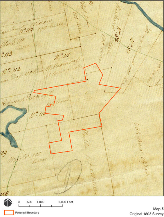
The Town of Sullivan was surveyed in 1803 under order of the General Court of Massachusetts, with settlers provided properties of 100 acres for a payment of $5.00. According to Hancock historian Lois Johnson, when the land division occurred, a public lot was established to provide firewood to the school(s) (Johnson, 2016). George Varney reported in his 1886 Gazetteer of the State of Maine that 9,000 acres of land in Sullivan was given to Bowdoin and Williams colleges. Maps of the original allotment of Crabtree Neck identify a public lot of 231 acres, and 584 acres and 34 square rods of “college land.”[3] By superimposing the boundary of Pettengill Preserve on the 1803 plan of settlement, the current preserve contains portions of Edward Pettengill’s estate, the public lot, college land, and possibly small portions of the estates of Richard Clark and Henry Grant (Map 5).
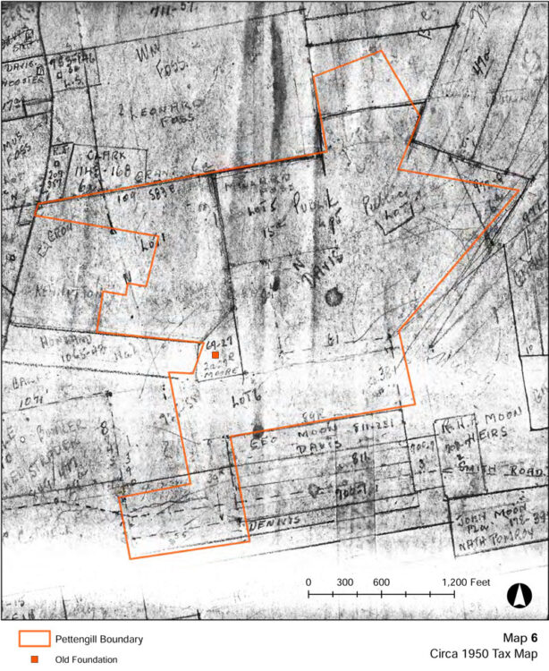
An old building foundation within the preserve (shown in Map 6) is located within a 2+ acre parcel of land sold by Edward Pettengill to Ebenezer Moore in 1831 for $30 (Exhibit A). The Pettingell Genealogy identifies that Edward’s daughter Jane married Samuel Moore of Hancock and had eight children, one of which was named Eben (Exhibit B). It seems likely that the old foundation is the house site of Ebenezer Moore, the grandson of Edward Pettengill. No further information on Ebenezer Moore has been found. The foundation is approximately 21 feet by 21 feet. A smaller foundation (approximately 4 feet by 5 feet) is located approximately 50 feet west of the foundation, and may be the remains of a well or outhouse.
The primary land use of the preserve has been the harvest of wood, first for lumber and then for firewood and possibly manufacturing. Varney (1886) recorded the presence of two mills in the town of Hancock, one mill manufacturing [barrel] staves, shingles and long lumber, and one mill producing staves and short lumber.
The 1878 Maine Board of Agriculture Survey describes the state of forests in Hancock County:
“Originally, pine, spruce, hemlock, birch, beech, maple, ash, cedar, red oak, and hackmatack, were abundant. But the waster of “God’s first temples” came, and before the insatiable chopper’s axe the primeval forests have disappeared, until, excepting the upper branches of Union river, scarcely a representative tree is left, and our once well timbered county, in its old growth is almost treeless; while the demands for stave timber, box stuff, vessel wedges, and fuel for lime kilns, are rapidly divesting it of its second growth (Wasson, 1878).”
The preserve has been repeatedly harvested over the last 200 years. Some old wire fencing exists along some of the boundaries indicating that some of the preserve or the adjacent lands may have been used for grazing of cattle or sheep.
[1] Varney (1886) identifies Waukeag as an Indian name for seal. A key source for Varney seems to be A Survey of Hancock County by Samuel Wasson published by the Maine Board of Agriculture in 1878.
[2] Sullivan was incorporated as a town of the State of Massachusetts in 1789. Maine seceded from Massachusetts in 1820. Hancock was incorporated in 1828.
[3] The original James Peter’s survey only identifies the remainder as 584 acres and 34 rods; however, at least one subsequent copy identifies the area as “college land.”
Conservation Values
The preserve provides an uninterrupted expanse of high-quality wildlife habitat. Key attributes:
- 150 acres of mixed forest is the largest preserve on Crabtree Neck and the second largest preserve in the Town of Hancock.
- Forested wetlands provide watershed protection.
Threats to Conservation
Spruce Budworm
The eastern spruce budworm (Choristoneura fumiferana) is a native insect that causes major damage to Maine’s spruce-fir forests on a regular cycle. Spruce budworm (SBW) caterpillars feed on the buds and needles of fir and spruces. Under normal (endemic) conditions populations of this insect are so low that SBW is hard to find. Periodically the budworm undergoes a population outbreak (epidemic) and becomes so abundant that serious feeding damage occurs. During epidemics defoliation is heavy enough that affected trees produce very little wood and many trees die. These outbreaks occur every 30 to 60 years. Severe defoliation is occurring in southern Quebec, and Maine’s SBW Task Force expects to see outbreak populations of SBW in Maine beginning within the next three years (SBW Task Force, 2016). Because the preserve is mostly spruce-fir forest, there is a significant risk of defoliation and tree loss.
Climate Change
The average annual temperature across Maine warmed by about 3.0 °F (1.7 °C) between 1895 and 2014. Since 1895, total annual precipitation has increased by about six inches (15 cm), or 13%, with most of the additional amount falling in summer and fall (Fernandez et al, 2015). These trends are expected to continue, with the region becoming warmer and wetter. However, some climate models predict drier summers (Janowiak, et al, 2018).
Current modeling studies project that the dominant tree species in the region are likely to undergo dramatic range shifts as forests slowly adapt to changes in habitat conditions over the next 100 years. Projections suggest that suitable habitat for spruce-fir forests may virtually disappear from Maine in the next 100 years (Rustad et al, 2012). Under a low-emission scenario, habitat suitability will favor a transition to maple/beech/birch (northern hardwoods) forest, while oak and hickory trees would be favored under a high-emission scenario (Iverson et al, 2008). How forest composition will be affected by climatic changes will be influenced by many factors. The long life span of trees, the slowness with which they disperse, and the possibility that they may adapt genetically to changed climates all make it unclear how soon, if ever, trees will migrate to the places where the models say they should be (Rustad et al, 2012).
Fire
Periods of hot, dry weather occasionally lead to high forest fire risk in the region. The preserve’s forest has areas of thick spruce and fir that provide a substantial fuel source. Available fuel may increase if a spruce budworm epidemic defoliates and kills spruce and fir trees.
Permitted Activities
Preserve guidelines are posted near the trailhead at the Point Road parking area.
Permitted Activities
Hiking, snow-shoeing and cross-country skiing are permitted during daylight hours. Dogs are permitted but must be kept under control. Hunting is not expressly prohibited.
Restricted Activities
Motorized vehicles are strictly prohibited. No camping or fires are permitted. All trash, including pet and human base, must be carried out. No bicycling is permitted.
References
Johnson, Lois. 2016. Personal Communication, October, 2016.
Fernandez, I.J., C.V. Schmitt, S.D. Birkel, E. Stancioff, A.J. Pershing, J.T. Kelley, J.A. Runge, G.L. Jacobson, and P.A. Mayewski. 2015. Maine’s Climate Future: 2015 Update. Orono, ME: University of Maine. 24pp.
Foss, Thomas. 1870. A Brief Account of the Early Settlements Along the Shores of Skilling’s River.
Iverson, L.R., A.M. Prasad, S.N. Matthews, M. Peters. 2008. Estimating potential habitat for 134 eastern US tree species under six climate scenarios. Forest and Ecology Management. Volume 254, Issue 3, 10 February 2008, Pages 390–406
Janowiak, M.K., et al. 2018. New England and Northern Hew York Forest Ecosystem Vulnerability Assessment and Synthesis: A Report from the New England Climate Change Response Framework Project. USDA General Technical Report NRS-173.
Maine Historical Society, 2010. Maine History Online. Available at: https://www.mainememory.net/mho/; Accessed November, 2016.
Morehead, Warren, K. 1922. A Report on the Archaeology of Maine. Andover, MA.
Penobscot Marine Museum, 2012. Penobscot Bay History Online. Available at: http://penobscotmarinemuseum.org/pbho-1/; Accessed November, 2016.
Pope, Charles, H. 1906. A Pettingell Geneaology. Boston, MA.
Rustad, L., J. Campbell, J. S. Dukes, T. Huntington, K. F. Lambert, J. Mohan, and N. Rodenhouse. 2012. Changing Climate, Changing Forests: The Impacts of Climate Change on Forests of the Northeastern United States and Eastern Canada. USDA General Technical Report NRS-99.
SBW Task Force, 2016. Spruce Budworm. Available at: http://www.sprucebudwormmaine.org/; Accessed December, 2016.
Varney, Geo. J. 1886. History of Hancock Maine from A Gazetteer of the State of Maine, B.B. Russell, Boston.
Wasson, Samuel. 1878. A Survey of Hancock County, Maine. Maine Board of Agriculture Survey. Augusta.
Click to view larger and download PDF